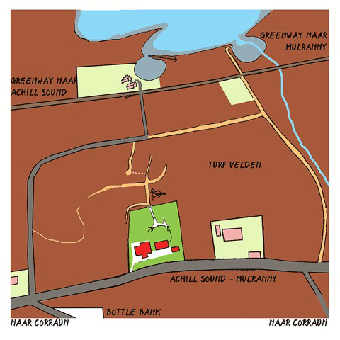
De directe omgeving
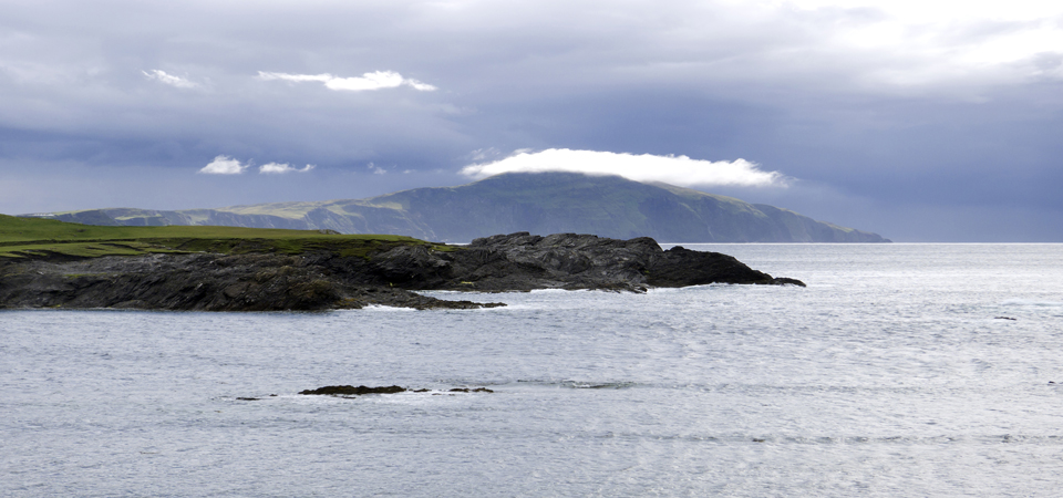
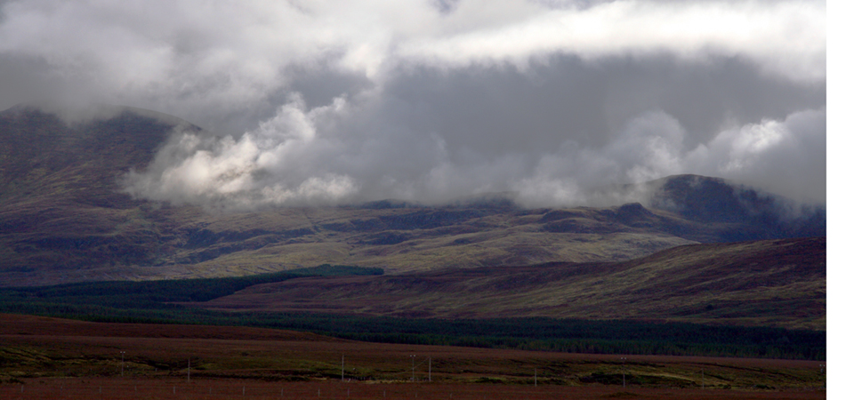
Het Polranny Huis ligt op de Corraun Peninsula. Het is een ruige omgeving omgeven door inhammen van de Atlantische Oceaan met grootse vergezichten, bergen en eilanden. Zo ligt het huis tussen de Polranny Mountain en een inham van de Atlantische Oceaan die Black Sod Bay heet. Benamingen beschrijven vaak de locatie. Zo betekent Polranny het “dal van de varens” en Black Sod Bay “de baai van de zwarte turfklompen”, een verwijzing naar het afgekalfde hoogveen langs kust.
Achill Sound: voor de boodschappen
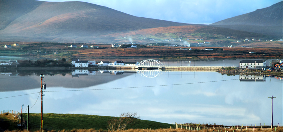
Achill Sound kun je via de Greenway bereiken. Er is hier van alles te krijgen omdat er traditioneel schepen bevoorraad werden. Het ligt aan de nauwe doorgang (sound) tussen Achill Island en de Corraun Peninsula. De naam betekent “zeeëngte van de zeearend”, afgeleid van het Iers voor zeearend: Accail.
Achill Island: surfen, kanoën, golfen, zwemmen
Achill Island (Accail in het Iers) ligt ca. 1,5 km ten westen van Polranny en is met het vasteland verbonden door de Michael Davitt brug. Het is het grootste eiland van Ierland en steekt ver uit in de Atlantische Oceaan. Het is beroemd om z’n ruige natuur, de hoge bergen die verticaal uit de oceaan oprijzen en de gouden zandstranden. Je kunt er surfen, kanoën, golfen en zwemmen.
Sinds de begintijd van de luchtvaart zijn de kliffen van Achill Island het laatste dat je van Europa ziet voordat je de oversteek maakt naar Noord Amerika.
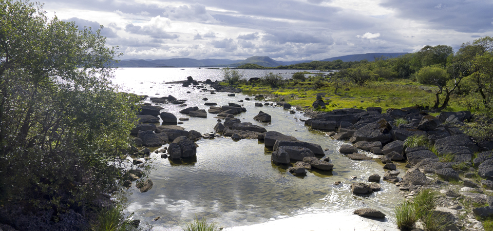
Corraun Peninsula: wandelen in het wild
Polranny (Polraithní in het Iers) ligt op de Corraun Peninsula. Het mooiste wandelgebied in de verre omtrek ligt letterlijk vóór de deur: de Polranny en de Corraun. Meren, rotspartijen, bosplantages, ‘blanket bog’ en alles wat er bij hoort, een gebied van 58 vierkante kilometer. En nauwelijks of geen mensen. Naar verluidt broedt hier sinds kort weer de zeearend die decennialang niet meer gezien was. Het is daar echt genieten voor de liefhebbers. Bij helder weer kan je honderd kilometer in de rondte kijken.
Fietsen over de Greenway
Achter het Polranny Huis loopt langs de kust een prachtig wandel- en fietspad (Greenway) Het is ongeveer 50 km lang en het loopt van Westport via Mulranny, Tonregee en Polranny naar Achill Sound en Achill Island. Het is voor de oplettende wandelaar te bereiken vanuit de achtertuin van het huis. De Greenway voert je door een streek die al 5000 jaar wordt bewoond, en met een bewogen geschiedenis die buiten de culturele ‘mainstream’ van Europa valt.
Meteen ten oosten van Polranny, ligt het buurtschap Tonragee, oud Iers voor: omgeving met-de-kont-tegen-de-wind, een verwijzing naar de rukwinden die hier tijdens een storm gevaarlijk heftig kunnen zijn.
Na Tonragee volgen in oostelijke richting: Mulranny (Malaranny), de afslag naar Ballycroy, Westport en Castlebar ten oosten ervan.
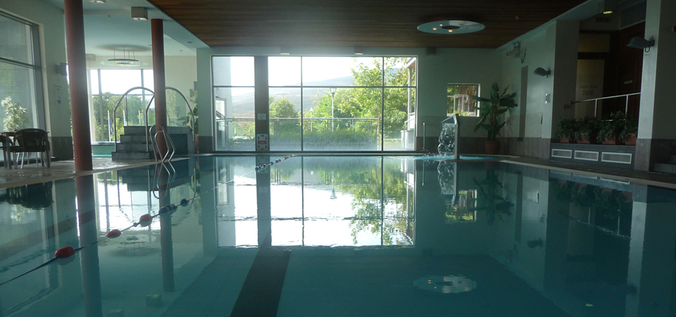
Mulranny heeft een hotel met zwembad
Mulranny is een badplaatsje. Behalve prachtige, veilige stranden heeft het een publieke golfbaan en een gerenommeerd, historisch hotel, het Great National Mulranny Park Hotel. Het staat bekend om een goede keuken, een gym, een zwembad, met allerlei extra faciliteiten, zoals een verwarmde jacuzzi, steam room en een sauna. En een Fitness en Beauty Centre op het terrein achter het hotel (inlichtingen bij de receptie).
Ballycroy
Ballycroy is een uitgestrekt bergachtig buurtschap Bellagragher Bay, “de baai van de plunderaars”. Het heeft een National Park en herbergt de eerste en enige Wildernis in Ierland, en het grootste veengebied van Noordwest-Europa.
Westport
Westport is het toeristenplaatsje bij uitstek. Het is charmant en het biedt veel voor jong en oud. Voor de muziekliefhebber is er de pub Matt Molloy’s voor de traditionele muziek en de jamsessies met bekende en onbekende musici.
Castlebar
Castlebar is de hoofdstad van County Mayo. Het is niet groot maar het is de shopping stad voor heel de County. Het heeft een Cinecomplex en een kunstencentrum (the Linen Hall) en alle andere uitgaansmogelijkheden die een ‘college town’ te bieden heeft. Het National Museum of Country Life ligt 8 km buiten Castlebar aan de weg naar Dublin.
Heel County Mayo is trouwens doortrokken van prehistorische en vroeg christelijke geschiedenis. Bovendien is het rijk aan herinneringen aan de veelbewogen en lange, maar ook kleurrijke, Ierse vrijheidsstrijd. Tussen Westport en Castlebar liggen diverse meren.
Bekijk het werkverblijf van Stg.Polranny Pirates
The surrounding area of Polranny
The Polranny Pirates’ homeport is located on the Atlantic Ocean amidst countless bays, islands and inlets. It is a rugged area with grand vistas, mountains and sandy beaches.The House is situated between the Polranny Mountain and the tidal waters of Black Sod Bay. Each of these names describes the respective places to perfection: Polranny (or Polraithní in Gaelic) means ‘valley of ferns’ and Black Sod Bay refers to the peat moorland that has been worn away by sea erosion along the coastline.
Achill Island and the supermarket at Achill Sound
The name of Achill Island is derived from the Gaelic Accail: Sea Eagle. It is located about 1.5 km from the House, and is connected to the mainland by a bridge. This place and the adjoining village are known as Achill Sound, its name describing the narrow waters between the Island and the Corraun Peninsula as ‘the strait of the sea eagle’. Achill is Ireland’s biggest island and juts out into the Atlantic Ocean. It is known for its high mountains that rise vertiginously out of the sea and its golden, sandy beaches. Since the beginning of aviation, the cliffs of Achill are the last you will see of Europe before embarking on the crossing to North America. At the end of the bridge is a supermarket and hardware store.
Corraun
Polranny, where the House is located, lies on the peninsula of Corraun, but is part of the Achill Sound village. This area has been inhabited for the last five thousand years and has a rich history that is unique and completely unlike Europe’s cultural mainstream.The best walking area for miles around is literally on your doorstep, and encompasses both Polranny Mountain and the Corraun Peninsula. Here, you will encounter lakes, rocks, forests and blanket bog, and often without a soul in sight. On a clear day, the view from Polranny Mountain extends across the country for one hundred kilometres in every direction. Rumour has it that a sea eagle is breeding again in the Corraun Mountains, after a long period of abscence.
Greenway
The House also provides easy access to the Greenway, a first-rate walking and cycling path. It connects Achill Sound to the local town of Westport, a journey of approximately 50 km.
Ballycroy
Before reaching Mulranny on the way to Westport, you can take a turn around Bellaghrager Bay (Smugglers’ Bay), northwards which takes you through Ballycroy where another residence of Polranny Pirates is located.
Mulranny
Mallaranny is a local seaside resort, looking out on Clew Bay, 14 kilometers east of Polranny and connected to it by the Green Way. Apart from safe and beautiful beaches, it has a public golf course and an illustrious, historical hotel, the Mulranny Park Hotel. It is known for the high standard of its cuisine, its fitness and beauty centre and heated indoor swimming pool. You can even admire the stunning view of Clew Bay from the comfort of the Canadian hot tub!
Westport
Westport is the most popular local tourist town. It’s a charming place and has plenty to offer both young and old. For example, Matt Molloy’s pub is famous for its traditional Irish music. Matt himself was a member of the legendary Chieftains and is a world-class flautist.
Castlebar
Castlebar is the county town of County Mayo. It is modest in size but is the main shopping centre for the entire district. There is a cinema complex, an arts centre (the Linen Hall) and plenty of nightlife as befits a college town. Wherever you go, County Mayo is full of prehistoric and early Christian history along with the memories of the long and turbulent struggle for Irish independence. Between Westport and Castlebar you will find some fine examples of the many inland lakes of County Mayo.